City of Los Angeles, Public Works Department (LAPWD), Bureau of Engineering, Geotechnical Section, Potrero Canyon Park Technical Advisory Committee, Project Development and Final Design
Services Provided:
---------------------------
Project Management
Technical Advisory Committee
Community Outreach
Cost- Benefit Analysis
Multi-Agency Coordination
Design Team Oversight
Project Alternatives
Value Engineering
Flow Monitoring
Storm Water / Treatment
Basis of Design Report
Facilities Design
Facilities Maintenance
Hydrology & Hydraulic Studies
Plans, Specs & Estimates
Native Re-vegetation
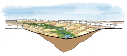
The 30 acre Potrero Canyon sits between the Palisades Recreation Center and PCH in Pacific Palisades and over the years, the loose soils have reduces the slope stability resulting in the rerouting of PCH, emergency slope mitigation, and potential impact to homes at the top of the canyon. LABOE – Geotechnical Division is the project manager providing a permanent slope stabilization solution and restorative riparian habitat to the community while including a park connecting Palisades Recreation Center to the LA County beaches. The project includes nine basins with a natural liner to retain as much water as possible for the riparian habitat, vegetation for slope and habitat restoration throughout the canyon, restrooms, soil cement lined path for hikers and emergency vehicles, and soil stabilized slopes. The project involves extensive stakeholder coordination with local, Los Angeles agencies.
MARRS led the planning and civil engineering for developing 30 acres of sustainable revegetation and park expansion at the coastal Pacific Palisades Community Center along Pacific Coast Highway. MARRS conducted several consensus building workshops involving several city departments and the community. The resulting innovative design solutions allowed for elimination of potable water use in favor of a more sustainable irrigation source by diversion, capture, and treatment of storm drain dry weather flows and wet weather runoff. MARRS verified source water through flow monitoring and measurement, prepared the hydrology and hydraulics reports as well as the water balance calculations. MARRS managed the development of project alternatives, cost-benefit analysis, and authored the basis of design including the 30% design plans. For the 100% design, MARRS has worked with a team to develop a final landscape design, path, wet well diversion pump, slope stabilization, traffic control plans, SWPPP, water pollution control plans, and initial site assessment for any hazardous materials and hydrology report. The final design included addressing comments from all the stakeholders described above, and obtaining permits from all jurisdictions including LADBS, Caltrans, and the California Coastal Commission.
MARRS provided an alternative analysis for the most cost effective, safest way to connection pedestrians, while showcasing a creative bridge that would be a landmark to the area while keeping the sightlines to the beach and canyon.
Project Features:
• Slope Stabilization
• Park Development
• Water Reuse
• Landscaping